Lunar Geomorphology
1. Lunar topographic features
Lunar surface is covered with a great number of craters excavated by impacts of relatively small sized bodies in the solar system. Secondary craters, crater chains, and grooves are also found around huge craters called impact basins. Domes, rills, pyrotic deposits, and other topographic or geologic features related to volcanic activities are also observed all over the Moon. Here we review lunar global topographies briefly.
Lunar surface is generally divided into three types of terrains; the mare, highland, and South pole- Aitken basin. The mare regions are topographically low and observed easily as dark patches or areas even with naked eye. Circular mare was originally huge impact basin whose diameter was several hundred km or more. The dark pattern of mare covered with basalt, which erupted after several hundred million years of formation of the impact basin, is so conspicuous that people in the world identified it as a rabbit, crab, an old woman’s face, etc.
However, the mare region covers only 17% of the whole lunar surface, and there are few mares on the far side of the Moon. Most of the lunar surface is covered by the terrain called highland which is older, brighter and higher than mare region (the highest position is on the farside of the Moon).
Third terrain is the South pole-Aitken basin (SPA) which has diameter of about 2,500km and it expands from -20 degrees in latitude to the south pole on the far side. There is lunar lowest topography in this huge basin. SPA is also considered as an impact basin, but it is not perfectly filled with basaltic lave sheet differing from other circular mares. This feature may be caused from the relatively inactive volcanic activity due to low concentration of radioactive elements (U, Th, K, …) in the thicker crust compared with one of nearside. However, the cause of different crustal thickness between near and far side is not clearly revealed until now. Why and how such dichotomy appears is one of the main problems on the formation and evolution of the Moon as well as the Mars.
2. Lunar figure
The mean lunar radius is confirmed to be 1737.1357km by the topographic observation of KAGUYA-LALT. The radius is less than 1737.4km which has been used conventionally as the reference value for many years. The polar radius (1735.6604km) is about 2.2km less than equatorial radius (1737.9004km), thus the oblateness is 1/775.845, which is smaller than Earth’s value (1/298.257).It is known that there is an offset between the center of mass (COM) and the center of figure (COF) of the Moon in about 2 km since the beginning of the lunar exploration era. According to results of KAGUYA-LALT, COF is 1.93461 km away from the Earth toward the direction of (+202.40 deg.[lon.], +7.09 deg.[lat.]) compared to COM, roughly corresponding to the lunar highest position, which is considered to reflect the difference of the crustal thickness between near and far side of the Moon. Lunar oblateness and COM-COF offset give important clues to reveal when and how the lunar dichotomy is formed.
Development and operation of KAGUYA-LALT laser altimeter
In April 2006, RISE project in National Astronomical Observatory of Japan successfully developed a laser altimeter called LALT for precise measurement of the lunar topography.
LALT measured the distance from the KAGUYA (SELENE) main orbiter to the surface of the Moon by transmitting Nd and Cr-doped yttrium-aluminum-garnet (Cr-doped Nd:YAG) laser pulses every second. The beam divergence was 0.4 milli-radian, resulting in the laser spot size of typically 40 m on the lunar surface from the orbiter whose altitude is 100 km. We have created global lunar topographic data and map from the range data of LALT with ancillary data such as position of LALT in KAGUYA (SELENE) main orbiter, orbital position of the main orbiter, and laser direction of LALT. These are based on the alignment measurements before launch, from 2-way Doppler tracking of the orbiter from the ground station, and outputs from the star sensor in the orbiter, respectively.
The flight-model of LALT (LALT-FM) had been developed from 2001 through April 2006, then it passed the interface test with the main orbiter. With 15 science instruments including LALT, KAGUYA (SELENE) was launched from Tanegashima Space center on September 14, 2007 after the final compatibility test in the launch base. LALT performed lunar topographic observation from December 30, 2007 through June 10, 2009. Using data obtained by LALT, many research papers have been published on the Lunar figure, topography, sun-lit conditions, internal structure, and so on (Araki et al., 2013; Araki et al., 2009; Noda et al., 2008; Ishihara et al., 2009; Ishihara et al., 2011; Fok et al., 2011; Bussey et al., 2011).
Here, we summarize briefly the operation history and laser shot statistics of LALT. For the first three and half months of the mission, the observation status had been quite good; however, from 9 to 14 April, 2008, the laser power dropped about 5 mJ (~6%) by April 14, and we had to operate LALT intermittently during the remaining nominal mission phase in order to avoid a possible further loss of power and to investigate the cause of this phenomenon. In addition, one of the four reaction wheels (RW) of the main orbiter failed at the end of July 2008, resulting in a doubling of frequent AMD events (angular momentum de-saturation) from one event every 12 hours to one every 6 hours, which lead to not only the loss of LALT observation time but also the degradation of the orbit accuracy that was necessary for making accurate topography. The number of tracking station and observation time available for Doppler tracking were reduced after the end of the nominal mission period, resulting in a second negative influence for orbit determination. LALT observations had to be stopped for one and a half months after the failure of a second RW on December 26, 2008 to avoid contamination from the orbiter’s thruster which had to operate continuously to control the attitude of the orbiter. After the second RW failure, the altitude of the main orbiter was controlled down to 50 km for observations of the lunar magnetic field, and was maintained at 50 km ± 30 km until the final impact phase. LALT restarted 1-Hz laser ranging on February 11, 2009, which lasted until the end of the KAGUYA (SELENE) mission (June 10, 2009).
Total range data obtained by LALT amount 22,061,496 (recovery rate is 96.91%) and total topographic data amount 10,340,710; implying not all of the ranging data were not converted into topographic data. This is because orbit accuracy during the extended mission period could not be improved for data merging owing to less frequent orbiter tracking.
LALT data products, such as time series topographic data, global or polar grid data, and spherical harmonic expansion coefficients have been utilized for the investigation of the lunar figure, topography and internal structure. Recently, lunar global topographic data have been available from several resources, such as KAGUYA-LALT (Japan), KAGUYA-LISM-TC (Japan), LRO-LOLA (USA), and Chang’E-LAM (China). Our LALT team firstly analyzed and published lunar global topographic results among these groups. LALT data products have been opened for public use from JAXA since November, 2009, and from NAOJ since November, 2011.
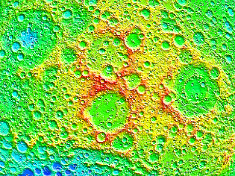
The terrain around the highest position
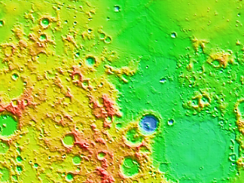
The terrain around the opposite side of the highest position
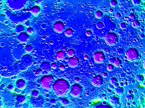
The terrain around the lowest position
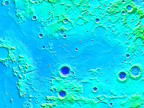
The terrain around the opposite side of the lowest position